
What is territory planning and why is it key to sales performance?

Contents
Sales optimization: planning territories with data
Cost pressure and the need to do more with less have led many companies to rethink their sales strategies. Territory organization is one of the critical points. Yet it is still common to find overly basic approaches, such as drawing zones based solely on the number of outlets, without taking into account the real potential of each area. In this article, we look at what territory planning is, why it is a strategic tool for sales teams, and how to move beyond traditional approaches to improve performance.
1. Territory planning: definition and objectives
Territory planning, or sales territory design, consists of dividing a geographic market into balanced, coherent zones so that each field sales rep is assigned a part of the territory they can manage effectively. It is not just about sharing out outlets: the goal is to optimize field resources, maximize business opportunities and avoid both saturated areas and areas left without coverage. The criteria commonly used to define territories include the number of outlets, the potential or historical revenue of each area, and geographic characteristics such as distances, travel times, territorial dispersion and the urban or rural nature of the area.
2. Why is it essential for your company?
Good territory planning has a direct effect on the effectiveness and profitability of the sales team. Above all, it increases revenue by focusing effort on high-potential areas, prioritizing the most profitable visits and improving the return on each sales action. It also helps cut costs and save time by minimizing unnecessary travel, optimizing routes and improving the planning of overnight stays. And it keeps the team motivated, avoiding inequalities between reps and making sure everyone has real opportunities to reach their targets.
3. The limits of Excel and traditional approaches
Many companies still rely on tools such as Excel to plan their territories. Although it may seem like an easy, accessible solution, this approach has significant limitations. A common example is a company that divides its market by assigning each rep 200 outlets, without taking into account the potential of each area or geographic dispersion. As a result, reps working in rural areas drive up to three times more kilometres than their colleagues in urban settings. Some reach their targets easily, while others struggle for lack of real opportunities. What's more, a tool like Excel makes it difficult, if not impossible, to factor in road density, real travel times or the economic potential of each customer or territory. Nor does it let you simulate scenarios for reorganizing the team or the territory.
4. A modern approach: data-driven territory planning
Moving beyond the limits of the classic approach means putting data at the centre of the process. Advanced territory planning combines multiple criteria to build truly balanced territories. It cross-references data such as the number of customers or outlets, revenue potential, customer type (independent stores, large retail chains, etc.) and logistical constraints such as distances, accessibility or the time needed to cover each route. It also relies on geographic visualization tools that make it possible to analyze and adjust territories dynamically and interactively.
The same sales force can face very different realities depending on the criterion used to draw its territories. Let's look at an example. The following figures compare two territory designs generated with Datakiss for a sales force covering Spain.
The first was built by assigning zones based on the number of outlets. The second takes total workload into account, combining the number of planned visits and the distance to be travelled.
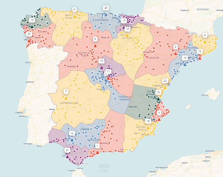
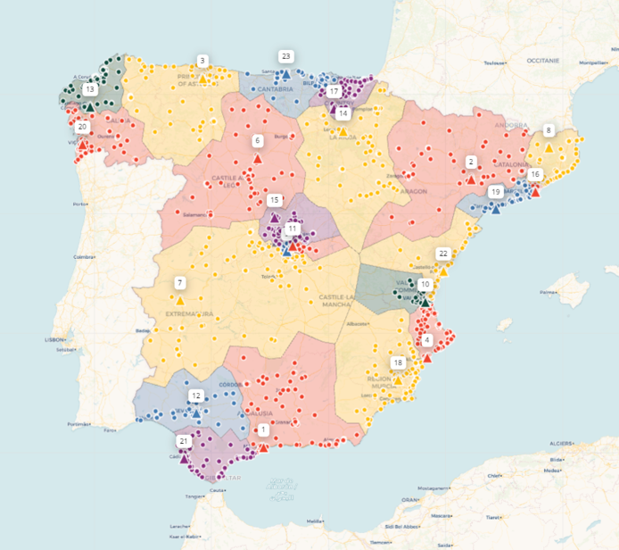
At first glance, the two maps may look similar in terms of geographic coverage. Yet they reflect radically different planning approaches. The first distributes territories according to a basic quantitative criterion: the number of outlets. The second also considers the effort involved in covering each area, combining visits, distance and logistical complexity.
This difference has very concrete operational consequences. While in the first case some territories are clearly overloaded, the second model aims to share the workload more evenly among the members of the sales team.
The difference between the two approaches becomes even clearer when we look at the workload distribution by territory.
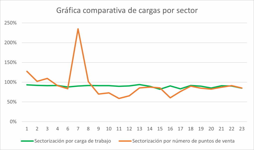
With workload-based optimization, the resulting territories are homogeneous: most sit at around 90% relative workload. This indicates a fairer distribution of sales effort, both in the number of visits and in time spent travelling.
By contrast, when territories are designed solely on the number of outlets, significant imbalances appear. For example, the Cáceres territory shows a workload of 234.8% and a very high travel volume. At the other end of the scale, territories such as Alcorcón record a much lower workload (69.9%) and considerably shorter distances (6,609 km).
This disparity has a direct impact on sales operations: while some territories concentrate too many logistical demands, others offer obvious room for optimization.
Overall, this approach makes it possible to build truly balanced territories, not only in customer volume but also in commercial value and workload. It also makes it easier to identify white spaces, high-potential areas not yet covered, and to accurately simulate the effects of adding new reps or redistributing areas before changing the organization of the team.
5. Comparing the approaches
| Approach | Territory design in Excel | Data-driven territory planning (e.g. Datakiss) |
|---|---|---|
| Main criterion | Number of outlets or historical revenue | Multi-criteria potential + geolocation and density |
| Time taken into account | No | Yes (real travel times) |
| Possible simulations | Very limited | Dynamic scenarios |
| Map analysis | Limited / manual | Interactive, updatable, instant |
| Gains achieved | Partial and often uneven | Optimized revenue, lower cost of sales |
6. Conclusion
Territory planning is much more than dividing territories by number of customers: it is a strategic approach that maximizes sales effectiveness and profitability. With tools like Datakiss, sales plans become growth levers, thanks to smart planning adapted to the realities of each market.


Get your territory design diagnosed.
30 minutes with a Datakiss expert to put your data on the table: real workload per territory, travel time, imbalances between reps. You leave with hard figures, not a brochure. Free, no commitment and confidential.

Sales management & performance
October 22, 2026
Campaigns, seasonality and events: how to anticipate their real impact on your sales force
Holidays, summer, major events: how to use data to anticipate the impact of each peak on your sales force workload, territory by territory.

Sales planning & visits
October 22, 2026
Visit frequency: why it should be a sales policy decision, not a team habit
Visit frequency drives workload and sales force sizing. Five steps to turn it into a sales policy your team can actually deliver.

In-store execution
October 22, 2026
Heading for Spain: a market to discover
Mercadona, private labels, in-store execution: Matthieu Laval (Nestlé) shares his keys to succeeding in the Spanish market.